Results

Clean filters

CarbonFootprintCapture1 thumbnailResultsCarbon footprint
October 16, 2026

Carbon footprint

An AI-based digital tool for comprehensively managing companies’ carbon footprints. It centralizes records and consumption data, automates data extraction and processing, applies emission factors, calculates GHG emissions, generates technical documentation, and facilitates offsetting through CO₂ absorption projects, thereby reducing manual tasks, processing time, and errors.
Screenshot: Truffle Farming 2 thumbnailResultsTruffle Farming
October 16, 2026

Truffle Farming

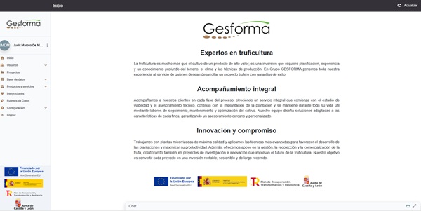
It is a specialized application for the management and technical support of truffle farming projects using artificial intelligence. It integrates a conversational assistant, a technical knowledge base, plot and project data, and tools for generating technical, financial, and suitability reports. It allows users to resolve inquiries, provides initial guidance to users, and supplies technicians with pre-structured and contextualized information.
featured forest navigator retechfor thumbnailResultsForest Navigator
October 8, 2026

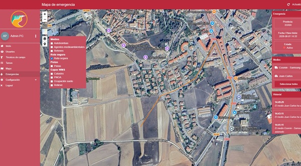
Forest Navigator

A system that allows users to navigate the network of forest trails in Castile and León, receive assignments, and send data collected in the field. It is connected to SINFO (the regional government’s emergency and fire management platform), which ensures that when an emergency is declared or resources are assigned to it, the devices involved receive an automatic alert with the assignment details and the fire’s coordinates. Information also flows in the opposite direction, as SINFO can access the data collected by the devices, and response teams can share safe routes within the same emergency.
hunting auctions retechforResultssubastasdecaza.com
October 8, 2026

subastasdecaza.com

An online platform through which the owners of the Regional Hunting Reserves in Castile and León list their hunting permits for sale, and hunters from all over Spain and abroad bid on them in real time, from home, without intermediaries and without having to be there in person.
Statistical Index Screenshot (thumbnail)ResultsStatistical-Climatological Index of Large Forest Fire Risk
September 11, 2026

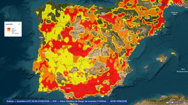
Statistical-Climatological Index of Large Forest Fire Risk

Statistical analysis and modeling of up to 15 climatological indicators derived from anomalies in temperature, humidity, precipitation, and wind, to generate a daily map characterizing the risk that a fire, once started, could develop into a Major Forest Fire (GIF), defined as one that exceeds 500 hectares.
Physical Simulator Screenshot (thumbnail)ResultsCharacterization of Forest Fire Spread (Risk) Using a 2D Physical Simulator
September 11, 2026

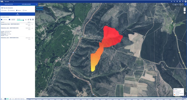
Characterization of Forest Fire Spread (Risk) Using a 2D Physical Simulator

Using the PhyFire model, developed by the University of Salamanca, users can select ignition points within a geographic area of up to 20 km² and obtain a map showing the expected progression of the fire.
Camera Screenshots (Thumbnails)ResultsAutomated Detection of Smoke Sources Using AI Models
September 11, 2026

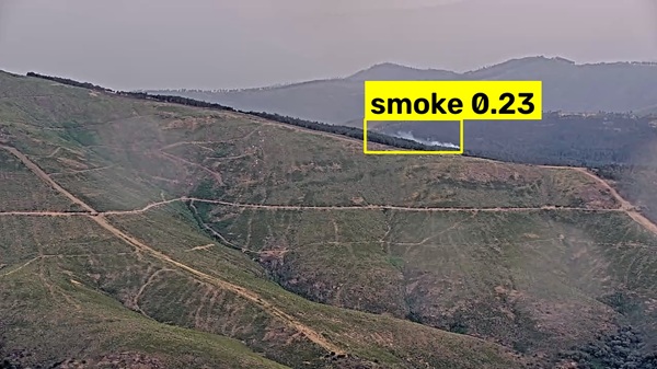
Automated Detection of Smoke Sources Using AI Models

Autonomous detection of smoke sources for any forest surveillance camera, all in real time, distinguishing between false positives and false negatives, to ensure the accurate and rapid detection of any smoke source within the field of view of the cameras in the monitoring network deployed in Castile and León.
GISAF thumbnailResultsGISAF
August 14, 2026

GISAF

GISAF is a modular web-based platform for comprehensive forest health management, developed for the Calabazanos Forest Health Center (Regional Government of Castile and León). It centralizes and digitizes the entire forest pest and disease management cycle: recording geolocated phytosanitary alerts, planning treatments, managing inspections, monitoring nurseries and forestry operations, and tracking pathogenic organisms.
ForestGPT thumbnailResultsForestGPT
August 14, 2026

ForestGPT

ForestGPT is an artificial intelligence assistant specializing in forest management for Castile and León. It allows forestry technicians and government officials to search, using natural language, the region’s forestry document repository: Zone Reports, the Forestry Atlas, ZEPA regulations, and the Castilla y León Forestry Plan. The system retrieves relevant information from the documents and generates accurate responses with citations from the original source, facilitating decision-making both in the field and in the office.
thumbnail inventoryResultsFirefighting Equipment Inventory Management
August 14, 2026

Firefighting Equipment Inventory Management

An inventory management module integrated into SINFO2 that enables comprehensive management of the entire lifecycle of materials, from their registration to their assignment to personnel or infrastructure, including historical tracking of each item.
FICYL thumbnailResultsDevelopment of the FICYL web application for managing courses, training programs, students, and instructors for the Castilla y León firefighting operation
August 14, 2026

Development of the FICYL web application for managing courses, training programs, students, and instructors for the Castilla y León firefighting operation

FICYL is the web application developed by the Center for Fire Defense (CDF) to manage courses, training programs, students, and instructors for the Castilla y León fire response operation. Its capabilities are being expanded to include a new centralized role and permission management system, a new certificate module with combined generation and automatic email delivery, and a system for customized queries to analyze training data.
thumbnail dimensionsResultsAutomated System for Generating Forest Fire Perimeters
August 14, 2026

Automated System for Generating Forest Fire Perimeters

Automatic generation of wildfire boundaries based on the most recent hotspots detected by the MODIS and VIIRS satellite instruments, with a constantly updated and reliable geographic delineation of active fires, which is essential both for firefighting operations and for feeding simulation models.
image(82) thumbnailResultsForest Fire Hazard Indices Related to Spread and Extinguishing Difficulty
August 7, 2026

Forest Fire Hazard Indices Related to Spread and Extinguishing Difficulty

It calculates and maps, on a daily basis, two forest fire danger indices in Castile and León: the HDWI index, which assesses the potential for fire spread based on atmospheric variables (wind and air dryness), and the geomorphometric index of firefighting difficulty, which analyzes the terrain (vegetation, slope, aspect, and proximity to infrastructure) to identify where firefighting operations may pose the greatest risk to the safety of firefighters.
AI Risk GIF ThumbnailResultsAutomated Identification of Hazards, Vulnerabilities, and Risks Associated with Large-Scale Wildfires Using Multispectral Images and AI Algorithms
August 7, 2026

Automated Identification of Hazards, Vulnerabilities, and Risks Associated with Large-Scale Wildfires Using Multispectral Images and AI Algorithms

Geospatial representation of data calculated by an algorithm based on artificial intelligence techniques capable of predicting with high accuracy the type and potential behavior of large-scale wildfires, thereby improving the accuracy of identifying areas that require vegetation management and fire prevention measures.
infrastructure 1 thumbnailResultsGeospatial Management of Defense and Critical Infrastructure
August 7, 2026

Geospatial Management of Defense and Critical Infrastructure

The tool allows users to record, update, and geographically display the defense and critical infrastructure of the INFOCAL operation—air bases, surveillance posts, garages and hangars, surveillance cameras, repeaters, and recreational areas—both from the command post (SINFO2, desktop version) and directly in the field (INFRIF, mobile version), keeping both systems synchronized in real time.
inforcyl 2 thumbnailResultsINFORCYL
August 6, 2026

INFORCYL

INFORCYL is the public platform of the Regional Government of Castile and León for providing citizens with live updates on wildfires: operational information and resources deployed, real-time location of the emergency, data on the area burned, multimedia content, and more…
Mipropiedad AppResultsApplication for the management of privately owned forests
July 17, 2026

Application for the management of privately owned forests

It is a suite of services for private forest owners and managers in Castile and León, offering decision-making tools for forest management: users can access data on forest parcels (mapping, stock levels, harvesting), estimate the profitability of reforestation projects, and seek technical advice from forestry associations. In addition, it compiles information on financial assistance for owners and communication with government agencies, as well as tools for advertising and buying and selling forest products.
Data Connectors and Data Apps RETECHFOR thumbnailResultsData Connectors and Data Apps in the Data Space
July 16, 2026

Data Connectors and Data Apps in the Data Space

Data Connectors integrate forestry information from databases, mapping services, APIs, documents, spreadsheets, sensors, and other sources into the RETECHFOR data space. Building on this data, Data Apps function as reusable processing modules: they can transform formats and models, combine datasets, anonymize sensitive information, validate data quality, semantically enrich the data, and perform inferences using analytical or artificial intelligence models. This results in structured, interoperable data without compromising governance, security, or the traceability of the exchange.
RETECHFOR Environmental Reporting System thumbnailResultsEnvironmental Reporting System
July 16, 2026

Environmental Reporting System

It is a multi-agent web platform designed to facilitate the preparation of environmental reports. The system combines artificial intelligence, geospatial analysis, and knowledge retrieval to process technical documentation, consult regulatory information, analyze a project’s potential territorial impacts, and generate maps and structured content. It allows users to create and version templates, organize reports by section, and automatically produce a final, editable document.
RETECHFOR Data Platform thumbnailResultsRETECHFOR Forest Data Platform
July 16, 2026

RETECHFOR Forest Data Platform

The RETECHFOR Forest Data Space is a federated infrastructure developed based on the specifications of the International Association of Data Spaces and Gaia-X, and adapted to the needs of the forestry sector in Castile and León. It allows government agencies, research centers, and companies to publish, locate, share, and use data without losing control over it.
SISILV resultsRetechFOR thumbnailResultsComprehensive Forest Signage and Inventory System
July 16, 2026

Comprehensive Forest Signage and Inventory System

SISILV is a digital ecosystem for the comprehensive management of forest surveys and inventories. It consists of a web platform for managers, a field app for data collection, and an app for tracking workdays.
CTME RetechFOR LD thumbnailResultsRetechFor-LD
July 10, 2026

RetechFor-LD

A web platform for transforming heterogeneous data into standardized, interoperable, and ready-to-use information. It allows users to create reusable templates that validate, transform, and map data (JSON, CSV, XML, or YAML) against ontologies, automatically generating JSON-LD (Linked Data) models compatible with semantic standards. The platform includes a visual editor, real-time validation, version control, token-based authentication, a REST API, and a monitoring dashboard for tracking executions, ensuring traceability, and detecting errors.
6. Forestry Transportation thumbnailResultsAutonomous Forestry Transportation and Forest Road Monitoring
July 10, 2026

Autonomous Forestry Transportation and Forest Road Monitoring

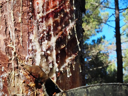
A robotic solution based on an autonomous vehicle, designed to support forestry operations. It is capable of transporting wood or firewood between a loading point and a storage point, can haul logs using a skidder module, and, during its trips, collects data using sensors and cameras to generate maps of potholes, vegetation, and the condition of forest roads.
5. Seed Dispersal 3ResultsAutonomous Ground-Based Robotic System for Intelligent Seed Dispersal in Forest Environments
July 10, 2026

Autonomous Ground-Based Robotic System for Intelligent Seed Dispersal in Forest Environments

A prototype autonomous ground-based robotic platform designed to operate in rugged forest environments and areas degraded by wildfires. It allows users to select a work area, plan coverage routes, and disperse seeds in a controlled manner using an electronic hopper, equipped with sensors to navigate, detect obstacles, and adapt its path to the terrain.
4. VA: Count of Treated LumberResultsAutonomous mobile robot with computer vision
July 10, 2026

Autonomous mobile robot with computer vision

A standalone air-to-ground solution that combines a drone with RTK and a quadruped robot equipped with LiDAR, 2D/3D cameras, thermal imaging, and computer vision. It allows users to plan missions via a web interface, capture georeferenced data in forests and sawmills, detect stacks of logs, count timber resources, estimate volumes, and classify conditions such as treated wood, resulting in a unified and auditable inventory.
3. Wood Traceability 2 thumbnailsResultsPrototype Machine Vision System for Raw Material Traceability at a Lumber Mill
July 10, 2026

Prototype Machine Vision System for Raw Material Traceability at a Lumber Mill

A computer vision solution that analyzes side and rear views of logging trucks, along with origin and destination data from the NEMUS system and open-source satellite data. The prototype detects, counts, and measures logs; estimates diameters, grades, and volumes; and recognizes license plates to automatically associate each load with the vehicle and verify the traceability of the raw material all the way to the mill.
combus scaled thumbnailResultsCOMBUS-IA CyL
June 26, 2026

COMBUS-IA CyL

COMBUS-IA CYL: Dynamic Classification and Quantification of Forest Fuels in Castile and León Using Remote Sensing and Artificial Intelligence Techniques
DECAPIN IA CYL General Example ThumbnailResultsDECAPIN-IA CyL
June 26, 2026

DECAPIN-IA CyL

DECAPIN-IA is an early-warning system designed to automatically identify and monitor signs of decline in Scots pine populations in Castile and León.
fococyl 1 image thumbnailResultsFöcoCyL
June 19, 2026

FöcoCyL

FöcoCyL is a web application that simulates the probability of a fire starting and its severity under given conditions, and thereby recommends silvicultural measures to minimize the impact of a potential fire through prevention.
preview 3 thumbnailResultsSilvatech
June 19, 2026

Silvatech

Silvatech is a digital solution for monitoring forest stands using 3D laser scanning, SLAM, AI, and precision georeferencing. It enables the creation of three-dimensional models of the forest, the measurement of heights, diameters, density, biomass, and vegetation changes, and the transformation of that data into useful information for forest inventories, risk prevention, and technical decision-making.
LiDAR IFC ThumbnailResultsContinuous Forest Inventory of Castile and León (IFC-CyL)
June 10, 2026

Continuous Forest Inventory of Castile and León (IFC-CyL)

The Continuous Forest Inventory of Castile and León (IFC-CyL) is a digital platform that integrates satellite imagery, LiDAR data, and field information to provide a constantly updated view of the region’s forests. It enables users to track the evolution of forest stands, estimate timber and carbon stocks, detect changes such as fires or logging, and generate alerts that facilitate more efficient, data-driven forest management.
Landsat from space thumbnailResultsAgroForChange (AFC)
June 9, 2026

AgroForChange (AFC)

This software solution integrates R and Google Earth Engine to analyze changes in land use over the past 20 years. It uses satellite time series (Landsat/Sentinel) and artificial intelligence (Random Forest) to automatically detect abandoned agricultural plots that are being converted into forest land. It is used to update forest inventories and monitor land-use changes on a large scale and with high precision. This is a specific technical contribution by Itagra CT within Action A.3.2 of RetechFOR for the continuous and automated inventory of forest resources.
resin thumbnailResultsObservatory on the Natural Resins Sector
June 9, 2026

Observatory on the Natural Resins Sector

The resin industry lacked transparency and accessible information on prices, the market, production, and profitability, which made it difficult for resin producers, landowners, and the industry to make decisions. Furthermore, Spain has a shortfall in miera—it needs at least 10,000 more tons to meet domestic distillation demand—highlighting the lack of tools to showcase the sector’s potential and foster scientific and technical cooperation for its development.
20260505 1st CIDIFOR CONGRESS DAY 1 91 thumbnailResultsAutonomous Robotic Platforms for Support in Forest Environments
June 9, 2026

Autonomous Robotic Platforms for Support in Forest Environments

Development of two autonomous robots for forest emergencies: one designed to provide connectivity in areas without coverage, and the other focused on detecting and assisting in the extinguishing of small fires.
web photo PDFCyL thumbnailResultsCastile and León Forest Data Portal
June 9, 2026

Castile and León Forest Data Portal

PDFCyL is a next-generation digital platform that integrates, visualizes, and analyzes forestry, environmental, and socioeconomic data from Castile and León. It allows users to view indicators, explore information through interactive map viewers, conduct spatial analyses, generate reports powered by artificial intelligence, and download data in multiple formats to facilitate data-driven decision-making.
OLYMPUS DIGITAL CAMERAResultsTruffleAuctions.com
June 2, 2026

TruffleAuctions.com

Web platform for managing online auctions of black truffles at the source. It allows users to list lots characterized by objective quality criteria and conduct automated online bidding between producers and traders, incorporating real-time analysis of supply and demand.
capturcyl results thumbnailResultsTelematic system for monitoring game hunting
June 1, 2026

Telematic system for monitoring game hunting

It is a digital solution consisting of a mobile app and a web platform that allows for the real-time recording and monitoring of game harvests in the hunting reserves of Castile and León. It replaces the traditional system of physical tags with a digital system, enabling more efficient, secure, and transparent tracking...
Forestwatch Virtual Reality Fire Goggles 2 thumbnailResultsXR Simulator
March 26, 2026

XR Simulator

This is a mixed reality (XR) simulation system designed to train forestry professionals in real-world field conditions. It recreates georeferenced fires superimposed on the real environment, allowing users to practice fire detection, tactical decision-making, and the application of safety protocols without physical risk...